Drive through history on Nevada highways
Most of Nevada’s highways began as old trails that were paved over.
Native people first conquered Nevada’s distances on foot, finding routes between water sources. After they acquired horses, they could go farther but still had to utilize available water and find forage.
When Europeans explored the continent, they used the same routes on foot or horseback but had to adapt old trails for wheeled vehicles pulled by horses, mules or oxen. Later, railroads altered routes to meet specific requirements. The automobile eventually dictated that most routes would be paved.
Explore Nevada on any of its major highways for a journey through history. Nevadans vacationing in their own state see unusual places and meet fascinating people. Unfortunately, many Nevadans living in our urban areas seldom venture beyond city streets. They miss what savvy foreign visitors travel thousands of miles to see. Travel websites lead many Europeans to our intriguing rural communities, ghost towns, remote deserts and lofty mountains. These intrepid travelers fly into our cities, rent RVs or motorcycles and set out bravely into our lonely, majestic distances for adventures most Nevadans don’t bother to experience.
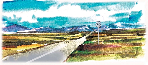
Because Nevada is so large and still sparsely populated, road travelers must plan for long distances. For safety’s sake, top off your fuel tank whenever you can, for the next service station might be half a tank away. Check your spare tire and know how to change a flat. Carry sufficient water for your vehicle and a gallon of drinking water for each person. Pack some nutritious snacks. Make sure everyone has a long-sleeved cover-up, for most places in Nevada cool off sharply at night, even in summer. Expect that cellphones will not work in some areas of Nevada. If you break down, stay with your vehicle.
Some travelers find Nevada’s vast outback intimidating because it dwarfs people and vehicles. Others find our landscapes gaunt and monotonous, even ugly to those used to expanses of greenery. But Nevada has a way of growing on you. Try to appreciate the bare-bones beauty of our endless series of mountain ranges separated by long valleys. Most days, an enormous bowl of shades of blue rests on the horizon. Notice the varied, subtle colors in landscape that change dramatically with the angle of the sun. Take note of our sunsets, and glance up at night for glimpses of dazzling skies hidden from city dwellers by artificial light.
From Las Vegas, historic routes fan out in every direction. Interstate 15 approximates parts of the Old Spanish Trail and the Mormon Trail while keeping the Union Pacific Railroad in sight. U.S. Highway 95 parallels early wagon, stagecoach and railroad routes. U.S. Highway 93 traverses the eastern part of the state from the Colorado River to the Idaho border, earning its scenic route designation along the way.
East-west routes across the state include Interstate 80, which cuts diagonally from the northeast corner of the state toward passes through the Sierras near Reno, the approximate route followed by wagon trains headed for the California gold country after the rush started in 1849.
U.S. Highway 6 enters Nevada with U.S. Highway 50 near Great Basin National Park. It slants across Central Nevada through Tonopah to the pass through the mountains into California near Boundary Peak, Nevada’s highest mountain.
U.S. 50, famous as “The Loneliest Road in America,” runs from the Utah border east of Ely to California at Lake Tahoe. From Central Nevada to Lake Tahoe, it follows part of the route of the historic Pony Express across nearly 500 miles of Nevada.
The Pony Express cut weeks off the time it took for mail to cross the continent – for a steep price. Completion of the transcontinental telegraph made nearly instantaneous communication possible, ending the daredevil horseback rides through all kinds of weather and dangerous situations after an 18-month run.
Each summer, the Pony Express of 1860-61 comes back to life when hundreds of horseback riders retrace the old mail-carrying route through seven states. Following the route west to east in relays, the riders will thunder through Nevada from Thursday to Saturday. They are expected to reach Genoa at 9 a.m. Thursday. A rider then heads on to Carson City. Others, in their turns, aim for Fort Churchill State Park, Schurz, ruins of old Pony Express stations and other points east, pushing on day and night. The last rider should cross into Utah about 8:30 p.m. Saturday.
Margo Bartlett Pesek’s column appears on Sundays.