Kodachrome Basin shouldn’t be overlooked
Eclipsed by one of Southern Utah’s stars, nearby Bryce Canyon National Park, beautiful Kodachrome Basin State Park should not be overlooked as a lesser light. It promises stellar scenery, fine facilities and varied activities without the crowds that surge into Bryce during vacation season.
Located east 20 miles of Bryce Canyon off scenic Highway 12, this high desert park lies 10 paved miles south of Cannonville near one of the side roads accessing the vast Grand Staircase-Escalante National Monument. Southern Nevadans reach this area in about four hours drive time. Follow Interstate 15 into Utah. Turn toward Zion National Park on Highway 9. Drive through the park to U.S. 89. Motor north to meet Highway 12 and turn east.
Stop in Cannonville at the regional visitor center for detailed information on the network of side roads and trails in the area that call to the adventurous. Keep in mind that once you leave the little towns along Highway 12, few services exist. Keep your vehicle fueled; check your spare tire; carry extra water; pack nutritious snacks; and charge up our cell phone before trying off-pavement excursions.
Watch for the turnoff toward the state park in Cannonville, a rural community with pioneer beginnings. Expect to pay $6 a day use fee when you reach Kodachrome Basin State Park. The park’s 2,240 acres preserve colorful sandstone cliffs and unusual rock formations that inspired its descriptive name during a 1948 National Geographic expedition. Members felt that the area just begged to be photographed and Kodachrome film was newly marketed then by the Kodak Corporation. Expedition leaders also named a nearby natural rock arch after longtime National Geographic chief Gilbert Grosvenor.
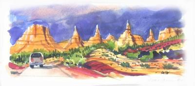
Called sand pipes, pipe intrusions or chimney rocks, the rock pillar formations stand alone, rising from the sand six to 170 feet tall. The monoliths likely formed as sediments around ancient geysers when the area was a lot like Yellowstone. Erosion carried softer sandstone away, leaving the unique columns standing by themselves. They seem to change color throughout the day with different sunlight angles and reflections off the cliffs.
Situated at 5,800 feet, Kodachrome Basin remains open all year, although cold weather and occasional snow force rangers to turn off water in the campgrounds in winter. Developments include a picnic area and a campground with 24 individual sites and a group area. Campers pay $15 per night for campsites suited for tents or RVs, available on a first come basis or by reservation at (800) 322-3770. For more information, call the park at (435) 679-8562. If you’d rather wing it, plan an early arrival in mid-week for best site selections.
Visitors may prefer to stay in one of six cabins available from a park concessionaire. Scenic Safaris rents out guest cabins, runs a handy little store, offers horseback trail rides and operates a stagecoach tour for visitors to the park. For more information or to make reservations call them at (435) 679-8787.
Hiking, mountain biking, photography and wildlife watching entertain park visitors. Check at the visitor center for maps detailing four easy trails within the park that explore among the cliffs and monoliths. Paved and dirt roads lead to scenic sites within the park. Off-road vehicle enthusiasts find excellent routes in areas near the park. Several times during the summer, volunteers from Bryce Canyon present “Kodachrome After Dark,” an astronomy program and stargazing opportunity using telescopes. Remaining dates include Aug. 25, Sept. 22 and Oct. 13. Bundle up as the nights are nippy.
The paved road to the park turns to a graded surface beyond the park. A designated Utah Scenic Backway and access road into the Grand Staircase-Escalante National Monument, the Cottonwood Canyon Road may be traveled in passenger vehicles. Do not attempt this 46-mile drive during wet weather. About 10 miles from the state park, watch for Grosvenor Arch, an elegant double formation. The route follows Cottonwood Canyon bordered by formations called the Cockscomb along Cottonwood Creek before it joins the Paria River. The scenic backway ends at U.S. 89 between Kanab and Lake Powell.
Margo Bartlett Pesek’s column appears on Sundays.