Titus Canyon an awe-inspiring route to Death Valley
Death Valley offers more miles of roads for exploring than any other national park. About 1,000 miles of paved and unpaved roads reach into most parts of the far-flung desert and mountain preserve.
Visitors planning road excursions within the park have a more fulfilling experience if they do a little planning. Equip yourself with a detailed map such as the one put out by AAA on the park and neighboring Mojave Desert areas. Check road conditions before you set out by visiting the Death Valley National Park website (https://www.nps.gov/deva/) or calling 760-786-3200. Be aware that flash floods during last fall and early winter forced the closure of some roads and traffic may be affected by repairs underway on other routes.
Of several possible entrance roads accessing Death Valley, the unpaved approach through narrow Titus Canyon remains the most dramatic. It requires a high-clearance vehicle since the road is rough. The 27-mile, one-way road offers spectacular scenery, a ghost town, ancient petroglyphs, narrow canyons, fossil-bearing stone and trails to several points of interest. You may spot bighorn sheep peering back at you from above. If you travel this road soon, you will find colorful wildflowers, part of this spring’s “superbloom,” which has now moved from the valley floor into higher elevations.
Approach Titus Canyon from state Route 374, the park entrance road from Beatty through Daylight Pass into Death Valley. Drive 115 miles from Las Vegas to Beatty on U.S. Highway 95. At a major stoplight downtown, turn left onto the Daylight Pass route. You will soon pass a little spur road to old Rhyolite and the ghostly statues featured at the Goldwell Open Air Museum.
As this side trip deserves ample time, and since you will need at least three hours to traverse Titus Canyon into Death Valley, save a stop at Rhyolite for another day. Continue on the paved highway a couple of miles more to the Titus Canyon turnoff.
Best driven in the cool months, this route through the Grapevine Mountains climbs for several miles after leaving the highway from Amargosa Valley. It continues through White Pass and onward to the highest point, 5,200-foot Red Pass, before descending through Titus Canyon into Death Valley. The journey through scenery, geological history and a colorful mining past attracts more adventurers to this route than any other backcountry road in the park.
At White Pass, the road enters upper Titanothere Canyon, an area of fossil-laden, colorful stone, named for a rhinoceros-like creature whose 30-million- to 35-million-year-old skull was excavated there in 1933. The road continues to climb to Red Pass, the divide between Titanothere Canyon and Titus Canyon. The overviews from this vantage point are splendid.
The road descends past the remains of Leadfield, site of a 1926-27 mining scam that left rusting relics, ruins and unstable diggings in upper Titus Canyon. A promoter duped investors with “salted” holes and flamboyant advertising, playing up the site’s proximity to Death Valley, famous for a few legitimate mining fortunes. Investors rarely bothered to investigate the promoter’s dubious and outright preposterous claims. Predictably, the promoter made off with all the money and Leadfield died.
Beyond the ghost town, the road drops toward Klare Spring, a miniature oasis that provides wildlife with water and fosters greenery and wildflowers. Native people depended upon water sources like this sheltered spring. These ancient visitors left signs of their passing in the form of petroglyphs incised on nearby stone faces.
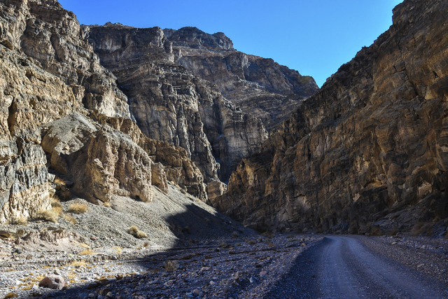
Titus Canyon grows increasingly narrow with cliffs rising hundreds of feet and shading the twisting canyon bottom. Evidence of titanic forces shaping the landscape is recorded in the folded, twisted layers of rock in the cliffs. Flash flood debris remains in high crevices of walls smoothed and burnished by the silt carried by floodwaters.
The lower three miles of Titus Canyon Road are open to two-way traffic. Death Valley visitors often park below the canyon’s mouth and hike up into the narrowest part of the route. Colors and shadows are most dramatic late in the day.
Margo Bartlett Pesek’s Trip of the Week column appears on Sundays.