Visitors will find recreation, beauty on Success Summit Loop
One of the prettiest drives in Nevada somehow missed being listed as a scenic back road or byway. Residents of the Ely area frequently recommend the 35-mile Success Summit Loop to those who want to explore back country. It takes travelers into a beautiful canyon, past popular Cave Lake State Park, over a forested summit, through a verdant valley dotted with ranches and past several fishing streams with camping facilities at the base of the lofty Schell Creek Range.
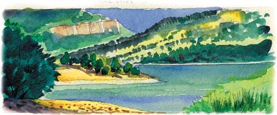
The southern end of the loop route begins eight miles south of Ely on U.S. 93 about 272 miles from Las Vegas. From the turnoff near Comins Lake, a paved road climbs seven miles through a canyon cut by boisterous Steptoe Creek to reach Cave Lake State Park. Situated in the woods at 7,300 feet elevation, this park centers upon Cave Lake, a 32-acre reservoir created by a dam on the creek. The park includes 1,240 acres surrounded by Humboldt-Toiyabe National Forest. Visitors pay a $4 per vehicle entrance fee.
The park offers picnicking, camping, hiking, fishing, wildlife watching and boating in summer. In autumn, the area supports hunting, as well as providing some of the best autumn color in the state. In winter, ice fishing, snowmobiling, cross country skiing and ice skating add to the year-round popularity of Cave Lake.
Two campgrounds serve visitors for an overnight fee of $14. Lake View Campground near the reservoir remains open all year. Elk Flat Campground across the road opens in May and closes in late October. Campsites are available on a first come basis. For best site selection, camp mid-week or plan an early arrival on weekends or holidays. Typical sites have tables, grills, parking pads, access to water and centrally located restrooms with flush toilets and hot showers.
Those using the park’s boat ramp pay a launching fee of $6. Anglers fishing Cave Lake, Steptoe Creek, Comins Lake or any of the other creeks in the vicinity must carry a valid Nevada fishing license and appropriate stamps. Obtain licenses wherever fishing gear is sold. Fishermen find brown and rainbow trout. Abundant crawdads provide fun catching them and good eating when cooked like mini-lobsters.
Two hiking trails originate in Cave Lake State Park. The popular three-mile trail along Steptoe Creek crosses the water on several foot bridges. The longer, steeper Cave Springs Trail covers about five miles. Both trails offer opportunities to observe wildlife and admire wildflowers at this time of year.
Many visitors arrive with off-road vehicles in tow. These may be used by properly licensed drivers on park roads, on the Success Summit Road and on other established roads. Motorized use of park foot trails is prohibited.
The paved road turns to gravel beyond the park as it climbs toward Success Summit, named for an early mine. Open from snowmelt to snowfall, this road is usually safe for passenger vehicles driven carefully, but side roads require high clearance vehicles. The road ascends in a series of swooping switchbacks with unparalleled views of rugged canyons and jagged peaks. Watch for elk and deer browsing in the meadows or gazing back at you from sheltering pines and firs. Often summer travelers on this road spot flocks of sheep with their picturesque herders and swiftly working dogs.
Stately aspen trees flank the meadows on the high mountain shoulders, framing superlative views. Summer blossoms riot in the sunshine of open areas. Huge golden blossoms of the wyethia dominate in many meadows, coloring whole slopes yellow. These showy blossoms bear the humble name “mule’s ears” from the shape of their large, fuzzy leaves.
Near the summit, pullouts mark informal campsites. As it drops down from the summit, the road heads north past the verdant pastures of ranches in Duck Creek Valley. Side roads explore several streams tumbling down canyons below the peaks of the Schell Creek Range. Rustic forest service campgrounds scattered along Timber, Berry, Bird and East creeks provide more opportunities for recreation where few other people go. Gravel gives way to pavement at the northern end of the loop, which rejoins U.S. 93 about 17 miles from Ely at a junction north of old McGill.
Margo Bartlett Pesek’s column appears on Sundays.