DEBORAH WALL: Bryce Canyon’s humanoid hoodoos make for visually stunning hikes
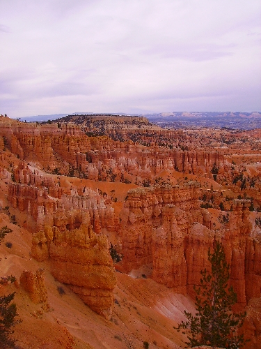


Along the eastern rim of Utah's Paunsaugunt Plateau lies Bryce Canyon National Park, a visual feast for the eyes. Standing along the park's rim, visitors are treated to a multi colored landscape of natural spires, pinnacles and pillars called hoodoos.
They got their name because their upright shape, with a little imagination, suggests humanoid or even supernatural beings. But these multi colored limestone formations are works in progress. They are formed primarily by erosion that takes place during the 200 freeze-thaw cycles each year. On sunny winter afternoons, snow and ice melt, and the water seeps into joints. Then, at night, it refreezes and expands, gradually cracking the rock and causing the cracked surface to crumble away over time.
Rain also helps in the weathering when runoff forms small gullies that leave narrow fins of rock between. When these fins develop weak places, they eventually become holes or windows. When the tops of these holes eventually collapse, a free-standing column remains -- a new hoodoo.
The park's elevations range from 6,620 feet at Yellow Creek to 9,115 feet at Rainbow Point.
If you visit the park over the next few weeks you can expect daytime temperatures averaging in the low 70s and nighttime lows in the high 30s. The park is open in winter as well, but snow often gets in the way of any quality hiking, although cross country skiing along the rim is a wonderful option. The park also boasts good air quality and low humidity, which from this high elevation makes it possible to see more than 100 miles on a clear day.
Depending on how much time you have in Bryce and your physical abilities, there are plenty of hiking opportunities. For an easy hike, the Rim Trail is tops. Although the Rim Trail extends about 11 miles, choosing to do one or more of its short segments is best. The half-mile section that runs between Sunset and Sunrise points is not only fairly level and paved but also has some of the best views into the escarpment.
For those seeking to get down into the hoodoos, the 1.3-mile Navajo Loop Trail is a fine one and is moderately strenuous. It was closed for a while due to rockfalls and mud slides but has reopened. The hike begins at Sunset Point and travels down into a nice slot canyon below the rim.
A more strenuous hike, and therefore one that offers quite a bit of solitude, is the Fairyland Loop Trail. It travels about eight miles and features the stunning formations called China Wall and Tower Bridge.
You can backpack in Bryce, though many people aren't aware of the option . The Under-the-Rim Trail travels about 23 miles from Bryce Point to Rainbow Point with eight backcountry campsites along the way. The other good choice is the nine-mile Riggs Spring Loop Trail from Yovimpa Point, which has four backcountry campsites.
For either you will need a backcountry permit available only at the park's visitor center, up to 24 hours in advance. It is strongly recommended to use a bear-resistant canister for food storage when camping. Bring your own or borrow one free of charge at the visitor center.
Seeing the park's hoodoos at night under the glow of a full moon is a sight you won't soon forget. On Sept. 11-13 or Oct. 11-13, you can take part in the guided Full Moon Hike. It takes 1½ to 2½ hours. These fill up fast. If you are interested, be sure to register at the visitor center first thing in the morning on the day of the hike.
Mule deer and pronghorns are the most commonly seen wildlife, although there are also mountain lions and the aforementioned bears.
Deborah Wall is the author of "Great Hikes, A Cerca Country Guide" and "Base Camp Las Vegas: Hiking the Southwestern States," published by Stephens Press. She can be reached at deborabus@aol.com.