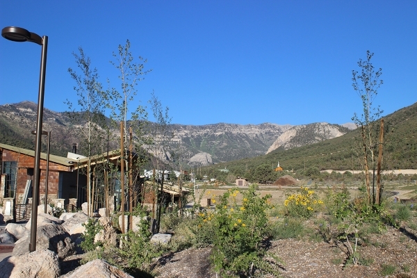
Spring Mountains visitor center a gateway to hiking

The Spring Mountains National Recreation Area encompasses about 316,000 acres and is part of the Humboldt-Toiyabe National Forest. The two most-visited areas of the recreation area are Lee Canyon and Kyle Canyon, about a 45-minute drive from the valley. Southern Nevadans and savvy tourists head here in summer for cooler weather and the pleasures of hiking, picnicking or camping among tall trees and mountains.
Any visit to this area should now start at the Spring Mountains Visitor Gateway, the new 4,500-square-foot visitor center in Kyle Canyon, which officially opened in late spring. This state-of-the-art, 128-acre complex includes an education building, two amphitheaters, a group picnic site, the nation’s first Cold War Memorial, the Nuwuvi (Southern Paiute) Seven Stones Plaza, and more than 40 miles of new trails.
Great thought was put into designing and building the complex to make it interesting and exciting for visitors of all ages. The interpretive signs throughout the compound are well-researched and informative, and even the smallest details were thought of. Look for painted wildlife tracks along the sidewalks and natural benches throughout. There are water stations to refill water bottles or hydration packs or draw water for dogs. As you stroll around the grounds, you will find native plants and trees, such as aspens, evergreens, and even this time of year, wildflowers.
Just behind the visitor center is the Cold War Memorial. Officially, it is the USAF 9068 Memorial and Silent Heroes of the Cold War National Monument and honors veterans and citizens who paid the ultimate price during almost 50 years of nuclear arms tension.
Charleston Peak, at 11,918 feet, is the tallest in the Spring Mountains range and was the site of the USAF 9068 plane crash during a winter storm on Nov. 17, 1955. The crash claimed the lives of 14 men who included Air Force personnel, scientists, engineers and CIA officials who were on a secret flight returning from Area 51, an air base whose very existence was never acknowledged by the government until recent years, which was used for developing secret weaponry such as the U2 spy plane. Besides the official memorial and interpretive signs telling about our involvement and other details of the Cold War, the propeller from the wrecked plane is on display outside.
The Seven Stones Plaza features seven boulders, one for each of the seven Southern Paiute Indian tribes, collectively known as the Nuwuvi. They circle a central stone that features a handprint that represents the Nuwuvi’s creator, Ocean Women. The Nuwuvi consider the Spring Mountains their creation place.
A visit here is especially rewarding for those who have children along. Just out of the back door of the visitor center, children will find all sorts of things to enchant them. There are kid-friendly interpretive signs, and beneath their feet, they will find the tracks of wildlife painted on the stones, fun to identify and follow. Here are walking paths of suitable short distances for little legs, and here they can take in a ranger program.
If you’re headed up to the Spring Mountains to hike one of your favorite trails, go prepared with up-to-date information from the Forest Service. Some trails in Kyle Canyon remain closed as a result of the 2013 Carpenter 1 Fire, and it’s occasionally necessary to close some trail for other reasons. Currently closed are the South Loop up to Mount Charleston and Griffith Peak Trail. Harris Springs Road and Griffith Peak Road are closed. Some campgrounds are closed or in limited use; you can get details by visiting gomtcharleston.com or by calling 702-872-5486. The website also contains a calendar of events in the recreation area, a link to a state site detailing current road construction likely to delay travel in the affected areas, and much other useful information.
The Spring Mountains Visitor Gateway is located in Kyle Canyon off state Route 157 and is open from 9 a.m. to 4 p.m. daily. All the trails are open from dawn to dusk.
— Deborah Wall is the author of “Great Hikes, A Cerca Country Guide” and “Base Camp Las Vegas: Hiking the Southwestern States,” published by Stephens Press. She can be reached at deborabus@aol.com.
From Las Vegas, take U.S. Highway 95 north about 20 miles. Go left onto Nevada state Route 157 (Kyle Canyon Road). Drive about 16.5 miles and turn left to the visitor center.