Off the Beaten Path


Just 20 minutes east of Kanab, Utah, a friend and I passed the sign informing us we were entering Grand Staircase-Escalante National Monument. This marked our official start of a five-day trip into the most western region of the park, called Grand Staircase. We could have made a good visit in much less time, but used five days because it was worth that many.
We were taking a 130-mile driving loop, mostly along unpaved roads around the upper reaches of the Paria River. Along the way we would stop and explore some of the most stunning geological features the area has to offer.
The monument, which celebrated its 10th anniversary on Sept. 18, was established in 1996 by President Clinton to protect the valuable scientific and historic resources of 1.9 million acres in south central Utah. The park, managed by the Bureau of Land Management, lies to the west of Bryce Canyon, north of the Arizona Strip, south of Capital Reef National Park and extends to the east to Glen Canyon National Recreation Area.
The monument is famous for its spectacular canyons. In the past decade I have experienced the beauty of many remote canyons in different regions of the park, but most of the time I had to travel long distances and use climbing gear to access them. Here though, there are a whole slew of spectacular canyons, accessible to any hiker, all in a matter of hours or less.
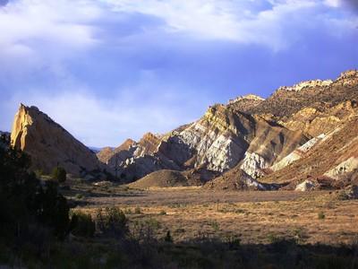
Our first two nights were spent camping off Cottonwood Canyon Road, the most eastern road on our loop and our main route heading north. This was not only near our first hiking destination, Hackberry Canyon, but below the Cockscomb, a segment of the East Kaibab Monocline, a fold in the earth's crust that runs from the Grand Canyon north and ends near Bryce Canyon.
Uplift, erosion, faulting and other natural forces have formed steep ridges and inclines, leaving vivid, colorful striped layers of sandstone and shale. We explored this natural wonder, climbing high along one sharp ridge, where we enjoyed views down into the tree-lined Cottonwood Canyon below, the prominent pure-white Castle Rock formation to the west, and far-reaching views of Table Cliff Plateau to the north.
The next morning, we were up before sunrise and heading up the mouth of Hackberry Canyon. A popular alternative to this is doing a 20-mile through-hike from the north, but that involves having two cars, one at each end of the journey, and a couple of extra days for exploring. Traveling from the bottom up has several advantages: There is a perennial flow of water in the lower 10 miles, the most striking narrow sections are near the lower end, and anyone can hike it.
The streambed, which serves as the trail, is shallow most of the time, except after heavy rains and run-offs. We found just a few inches of water in most places. Within 15 minutes we reached the narrows, where we found the Navajo and Kayenta sandstone walls rising more than 100 feet above, but only about 20 feet apart. Standing between them we saw a magnificent palette of colors: a bright blue sky and red, pink and orange sandstone, flanked at the base by the bright green leaves of cottonwood and box elder. At our feet, cream-colored sand with a ribbon of clear water flowing through it.
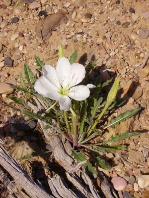
Although our main goal was to see the narrows, we headed upstream a few more miles. Seep willow and horsetails lined the narrow creek, and large, healthy cottonwoods grew along the water's edge.
There are many highlights in the lower canyon, but two destinations are worth seeing. About 2.5 miles from the trailhead is Watson's Cabin, a log structure complete with a stone fireplac. It's in pretty good shape considering it was built in the early 1900s. Another is Sam Pollock Canyon, the mouth butlies about a half-mile farther along. Altogether we ended up traveling only about five miles upstream, but with exploring the side canyons and upper benches, we probably totaled out at about 14 miles for the round trip.
On our second morning, we packed up camp and headed north on Cottonwood Canyon Road to our first destination of the day, Cottonwood Narrows. Early-morning driving brought the standard backroad dangers: a bobcat darting across the road, cattle standing their ground, and what seemed like hundreds of jackrabbits and cottontails racing for cover as we approached.
There are trailheads on either end of this easy one-and-one-half-mile hike, both on Cottonwood Road. We started on the most southerly one and within 10 minutes were within the tight canyon walls. The entire canyon is interesting and with each bend and curve a new delight appears. Instead of retracing our steps, we turned it into a loop, finishing with a mile-long walk along Cottonwood Road, lovely in itself, as this section is full of spires, hoodoos and other odd-shaped formations.
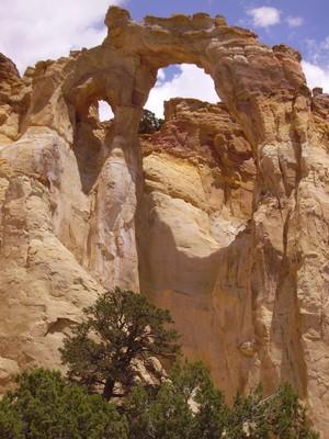
Continuing north we took a few short side trips, including stopping to see one of the most unusual formations in the monument, Grosvenor Arch. I was unable to get an authoritative measure of its height, but my guess is 40 feet for the sandstone arch itself, and its higher elevation puts the top perhaps 120 feet above the onlooker.
Then we headed out to see the sand pipes in Kodachrome Basin State Park. Geologists believe this was once a geothermal area of geysers that over time filled with sediment that solidified. Years of erosion wore away the surrounding material and left the columns of sediment standing. There are 65 sand pipes, most about 50 feet tall but some well over 100 feet high.
After reaching the most northern end of our loop we took a left onto Skutumpah Road. Over the years, I have come across many different types of animals in the middle of the road but it was quite a sight to round the corner and see two bison. One quickly headed off the road, while the other just stood there giving us the eye. I drove a bit closer but he still wouldn't budge. Not wanting to make him mad -- after all, he looked about 10 feet long and probably weighed close to a ton -- we waited him out. In about three minutes, he got bored and moved on.
For our two final nights we found an ideal campsite, within a pinyon-juniper woodland that provided views of the eastern escarpment of Bryce Canyon National Park, with its pink cliffs, to the west, and the massive Aquarius Plateau to the northeast.
The next morning we headed south on Skutumpah Road, about a mile from our campsite, to Willis Creek. From the trailhead, it was only a short two- or three-minute walk along the southeast bank of the drainage where we dropped into the streambed. Here, we found a pretty six-foot waterfall. We walked downstream about 10 minutes and found ourselves in another incredible narrows. The sandstone walls rise up about 200 feet and in some places it is only six-feet wide.
From the trailhead, Willis Creek travels 2.2 miles before ending its journey at the confluence of Sheep Creek. But we chose to go left after only a mile-and-a-quarter into Averett Canyon, making a hiking loop along the road. Averett Canyon is named for Elijah Averett, a member of the Utah Territorial Militia, who was killed in the canyon by Indians in 1866. It took some searching, but we found the grave and its two markers, a small round one and a larger, more rectangular one made of cobbles set in mortar.
Our next stop was Bull Valley Gorge, a must-see place even if you are not up for the challenges of hiking it. This is one of the best slot canyons in the area. The gorge was a scene of a deadly accident some 50 years ago,when three local men headed out on this road in a pickup truck and never returned. The group had plunged into the gorge and by the time they were found a couple of days later, they were all dead.
The truck is still visible, hanging from its last resting spot, wedged below the bridge, but you'll have to take the rim trail for about 50 feet located on the northwest side of the bridge to see it. The truck is now surrounded by boulders and gravel that were placed to make the new road bridge over the gorge. This new bridge is only wide enough to fit one vehicle. To make it worse, on each side there are areas of washouts allotting the driver just a foot or so on each side.
The only way to access this slot canyon without technical equipment is via the one-half-mile rim trail. This is not for anyone scared of heights, which I found out first-hand. After about 100 yards my hiking buddy turned pale, stopped in his tracks and said he couldn't go on. I walked him safely back to the trailhead, then returned on my own.
Accessing the gorge was otherwise easy, but once in the canyon I found a few obstacles. The first two are dry falls, one about 25-feet high but sloped and easy to maneuver down; the second shorter but a straight shot. Both had upended logs present, which I used to descend and ascend. A third dry fall was probably 20 feet straight down and a bit trickier and would have been easier with a rope and good anchor.
As I headed toward the bridge, the walls became higher and in most places the sky was hidden from me. I could easily touch both sides in this corkscrew of sandstone. Standing underneath, it was well over 100 feet looking up to the bridge. Since I did this one alone, I made it a quick in and out.
On our last day, we explored some rough side roads and then stopped at Lick Wash, another famous narrow hike. In less than 10 minutes, we were in the narrows. We followed the canyon until it opened up into a wide sandstone canyon and turned around. On the way out, looking up to the tops of a ponderosa tree, I noticed a three- to four-foot-wide bird's nest on a small ledge set high on the cliff face, perhaps 150 feet above me. Inside were what I believe to be four baby golden eagles.
You may have heard about a recent rockfall in Lick Wash, but rangers said it does not negatively affect the hike.
Taking a look at the trailhead registers throughout our trip, I saw the majority of explorers come from Utah's border states -- Colorado, Arizona and Nevada -- but there were also a fair number from Oregon and California. A side note: I am aware that many hikers, including some friends, refuse to sign trail registers out of principle, so this is not an entirely accurate depiction of where the majority are from.
If you are looking for some excellent narrow canyons to explore, even if you have the entire family along, Grand Staircase region is a great place to come. In a few of the canyons, we were the only ones visiting for the first time in days, while others were more popular. But even so, we found most people just travel as far as the narrow sections, then return. If you journey on, you'll have the place to yourself.
GETTING THERE
Location: Grand Staircase-Escalante National Monument, in south central Utah, about 250 miles from Las Vegas.
Directions to Kanab, Utah: From Las Vegas, take Interstate 15 north about 125 miles to Utah Route 9 (Exit 16, Hurricane/Zion National Park). Drive nine miles and go right onto Utah Route 59 east. This 61-mile paved road turns into Route 389 when you enter Arizona, and then into Route 89A north when turning left in Fredonia, just a few miles south of Kanab.
Directions for loop drive: Grand Staircase driving loop starts and ends seven miles east of Kanab on U.S. 89 at Johnson Canyon Road. From that intersection, take U.S. 89 east for 37 miles and go left onto Cottonwood Canyon Road. Follow this north for about 43 miles and go left on Skutumpah Road. Drive south for about 34 miles and go left on Johnson Canyon Road. Drive 16 miles farther to rejoin U.S. 89 and complete the loop.
Season: September-November, March-May.
Grand Staircase-Escalante National Monument: Managed by the Bureau of Land Management, www.blm.gov.
Contact Information: Kanab Visitor Center, 745 E. Highway 89, Kanab, Utah, (435) 644-4680. Cannonville Visitor Center, 10 Center St., Cannonville, Utah, (435) 679-8981.
Maps: Trailheads are unsigned, so carry a good map and mark your mileage along the way. Maps with trailhead information and mileage are available at monument's visitor centers.
Group size: All canyon hikes are limited to groups of 12 or less.
Lodging and services: Gasoline and limited supplies are available on the northern end of the loop in Cannonville. No other services along loop drive, but Kanab and Page, Ariz., have lodging, restaurants, gasoline, groceries and medical services. For Kanab information, (800) 733-5263, www.kaneutah.com; for Page, (888) 261-7243, www.pagelakepowellchamber.org.
Permits: Overnight permits required for all overnight car camping and backpacking. Permits are available at any of the monument's visitor centers, or you can self-permit at trailhead registers.
Primitive camping: Look for campsites that show signs of prior use. No camping at trailheads or within 300 feet of corrals, springs or streams. Camp stoves highly recommended; campfires allowed with metal fire pan. Bring your own wood.
Water: Filter water, treat it chemically, or boil it before drinking.
Hazards: Flash flooding. Always get a weather forecast before hiking any narrow canyon. Cell phones, radios and GPS units do not work in most areas.
Roads: Cottonwood Canyon Road and Skutumpah Roads are accessible to high-clearance vehicles, but a four-wheel-drive is highly recommended. If it rains, stay out; roads become impassable for all vehicles. Always get a weather report and travel update from monument staff before heading out. Carry extra gasoline and enough supplies to be stranded an extra night or two.