Though a difficult trek, Toroweap well worth the effort
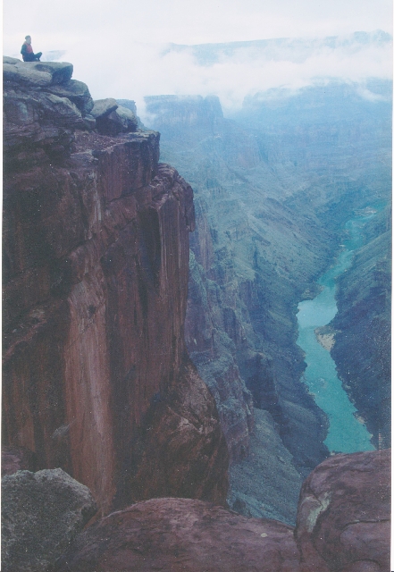


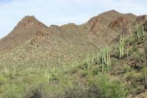
If you are up to traveling a long, rough and remote back-country road, you’ll be rewarded at the far end of this drive with one of the most breathtaking views in the West. This is Toroweap, also known as Tuweep, where you can stand directly on the rim of the Grand Canyon and see all the way down to the river that carved it, 3,000 feet below. You can see east and west, upstream and down, and you might even have this superb view all to yourself. Alone or with a loved one, it is a view you will not soon forget.
The site is on the extreme west end of the North Rim of Grand Canyon National Park, on the Arizona Strip. It’s not an excursion for everyone, as the quickest and most interesting routes involve a 90-mile drive out of St. George, Utah. Most of that road is gravel or washboard, with the last few miles over uneven sandstone, which makes a rough and slow slog. The rim, located at an elevation of about 4,600 feet, isn’t a place to bring small children, anyone unsteady on their feet or those afraid of heights, for there are no guardrails or safety measures. And yes, people have fallen and died.
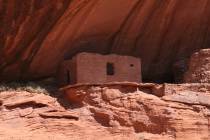
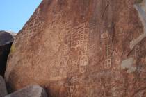
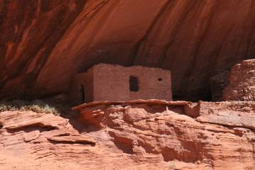
The road-trip portion is one of interest, as it goes by the Mt. Trumbull (Bundyville) one-room schoolhouse, where you can go inside and peek around. After the Mt. Trumbull area itself, and the highest elevation of the road trip, you can take a short side trip of a few miles, culminating in a hike of about 1½ miles round trip, to see the Nampaweap petroglyph site. One of the finest rock art sites on the Arizona Strip, this site has thousands of drawings from Archaic, Anasazi and Paiute art traditions.
At the Toroweap viewpoint, most visitors walk the 50 yards or so from the parking area directly to the edge. There, you can look down at the river. Most of the time, you will be able to see some rafts that look like tiny dots. Binoculars are well worth bringing. For a different view, walk to your right for about five minutes, to the end of the cliff. There, you can look downstream to Lava Falls, one of the canyon’s toughest rapids for river rafters.
The really adventurous and energetic sometimes hike down to Lava Falls, but from personal experience, I can tell you it’s one tough trek. It involves hiking down a steep hillside of scree and boulders, via a route marked only by cairns. It’s one of the hottest routes into the canyon, entirely without shade. And it’s also one of the steepest; the route is only about three miles round trip, but the elevation loss down to the river is about 2,500 feet since it starts below the Toroweap Overlook some miles away.
Towoweap might be the most remote place you ever drive to, but it’s up to you whether the experience changes your life or possibly ends it. You must prepare well for this trip. Your vehicle needs to be high-clearance and equipped with real off-road tires, two good, full-size spares and the tools to change them. The park service reports that 25 percent of visitors get at least one flat tire, which I experienced firsthand.
On this trip, you may operate your vehicle much more than usual in four-wheel drive or lower gears, so gas mileage may be less than normal; think about carrying extra gasoline. There are no services, and to get towed off the Arizona Strip can cost $1,000 to $2,000. And even calling for a tow could be difficult; cellphones do not work along this road, and I have seen times when I was the only visitor for a couple of days in a row. Therefore, bring more water than you think you could possibly need, as well as plenty of food and clothing warm enough for an unexpected overnight. Be aware also that the road passes through the Mt. Trumbull area, at about 6,500 feet, which can have snow even in spring.
There are nine nice camping sites available near the overlook, complete with fire rings, picnic tables and a pit toilet. The sites are available on a first-come, first-served basis, except for one group site, which is by reservation only, by email request. For more information, visit nps.gov/grca/planyourvisit/tuweep/.
Deborah Wall is the author of “Great Hikes, A Cerca Country Guide” and “Base Camp Las Vegas: Hiking the Southwestern States,” published by Stephens Press. She can be reached at deborabus@aol.com.