Las Vegas temperatures to dip a few days with a chance of rain


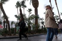
A little cooler and a lot more wind sums up the National Weather Service forecast for the Las Vegas region early this week.
A Monday high near 109 follows a 112 high on Sunday. The afternoon winds on the longest day of the year will gust up to 33 mph.
“The wind machine is going to crank up as the temperatures fall,” meteorologist John Adair said.
The official start of astronomical summer is tonight at 8:32pm PDT! It is the longest day of the year, with 14 hours 37 minutes of sunshine. Happy Summer! ☀️#SummerSolstice #nvwx #azwx #cawx #vegasweather pic.twitter.com/eUBcbu6jCB
— NWS Las Vegas (@NWSVegas) June 20, 2021
The low humidity, dry ground conditions and southwest winds prompted the weather service to call for red flag fire warnings Monday and Tuesday.
Red flag warnings
The Monday warning runs from noon to 9 p.m. and includes all of Clark County, most of southern and central Nye County as well as southwest Lincoln County.
Tuesday’s warning from 11 a.m. to 9 p.m. includes the same areas as well as much of central Nevada and Mohave County in northwest Arizona. Winds Tuesday will be pretty much identical to Monday’s conditions.
A high of 103 is forecast for Tuesday with a 100 expected Wednesday, which is a few degrees below normal.
Overnight lows in the lower 80s will decrease to around 80 on Wednesday.
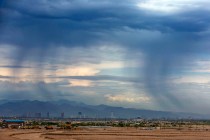
Tropical moisture
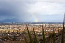
Moisture pulled up from the remains of a tropical storm far to the south will bring a 20% chance of rain Tuesday night going into Thursday, Adair said.
“It’s not a big chance, but Clark County could see some rainfall,” Adair said.
After cooler mid-week temperatures, conditions will warm next weekend to expected highs around 110 Saturday and Sunday,
Contact Marvin Clemons at mclemons@reviewjournal.com. Follow @Marv_in_Vegas on Twitter.