Winds help Las Vegas heat ease, but boost fire danger


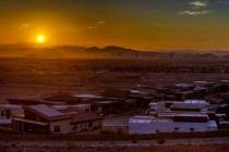
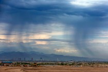
An elevated fire danger is forecast for much of the Las Vegas region for the next two days as record heat slowly drops back to normal, according to the National Weather Service.
“We’re highly confident we will have a high fire danger Sunday and Monday and possibly Tuesday and Wednesday,” weather service meteorologist Ashley Nickerson said. “We’re getting close to summer and fireworks could spread a fire quickly with the dry conditions out there.”
🔥Dry conditions & breezy winds will lead to high fire danger over the next few days. Obey all fire restrictions in place! #nvwx #azwx pic.twitter.com/mbVGUCyuLH
— NWS Las Vegas (@NWSVegas) June 5, 2021
The Sunday high should be near 104 after reaching 108 on Saturday at McCarran International Airport, a degree short of the 2016 record. Death Valley notched a 117.
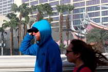
Winds that gusted close to 30 mph on Saturday afternoon and evening will kick back up Sunday afternoon, likely just a bit stronger, Nickerson said.
The Monday high will drop close to normal with a 97 forecast before a 95 on Tuesday. Gusty wind conditions are expected through the week.
Lake wind advisory
Steady winds of 20-30 mph and gusts to 40 mph will make for rough boating conditions. A lake wind advisory runs from noon until 8 p.m., says the weather service. Waves could reach 3 feet on Lake Mead and other area waters.
Contact Marvin Clemons at mclemons@reviewjournal.com. Follow @Marv_in_Vegas on Twitter.